1825 Illinois County Formation Map
Try our genealogy search engine
1825--TEN NEW COUNTIES
As counties of the State of Illinois
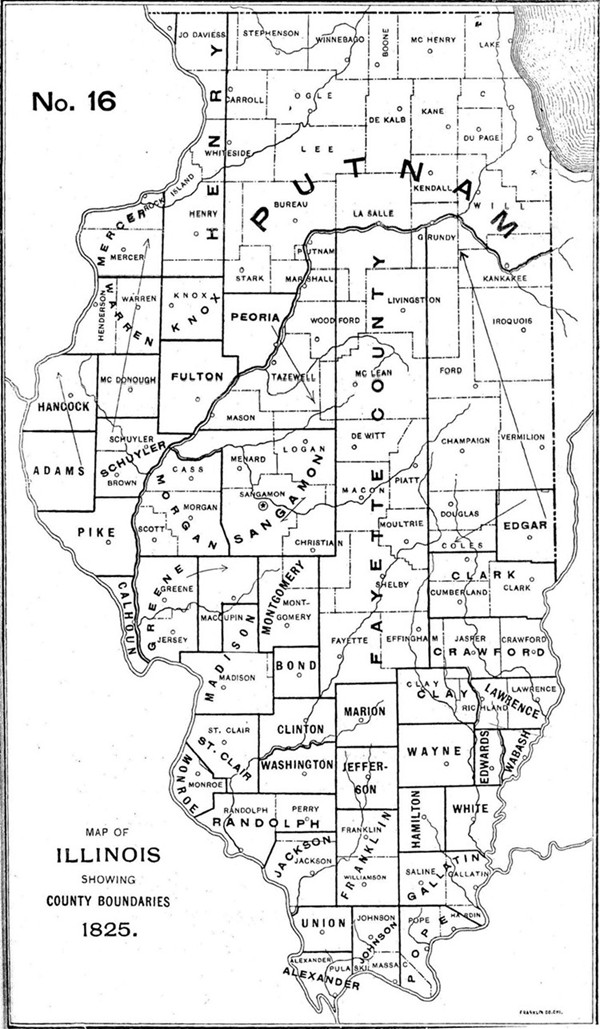
CALHOUN, Jan. 10--All that tract of country between the Illinois and Mississippi Rivers south of the line between townships 7 and 8 south.
[Laws 1825, p. 65.]
ADAMS. Jan. 13--From the southeast corner town three south, five west of the fourth principal meridian, west to the Mississippi; thence up the river to the line between towns two and three north; thence east to the northeast corner of town two north, five west; thence south to the beginning.
[Laws 1825, p. 98.]
HANCOCK, Jan. 13--East from the Mississippi on the line between towns 2 and 3 north, to the line between ranges 4 and 5 west, of the fourth principal meridian; thence north to the line between towns 7 and 8 north; thence west to the Mississippi; thence down the river to the beginning.
[Laws 1825, p. 93.]
HENRY. Jan. 13--East from the fourth principal meridian on the line between towns twelve and thirteen north, to the line between ranges four and five east; thence north to the Wisconsin state line; thence west to the fourth principal meridian; thence south to the beginning.
[Laws 1825, p. 94.]
KNOX. Jan. 13--East from the fourth principal meridian on the line between towns eight and nine north, to the line between ranges four and five east; thence north to the line between towns twelve and thirteen north; thence west to the fourth principal meridian; thence south to the beginning.
[Laws 1825, p. 94.]
MERCER. Jan. 13--East from the Mississippi on the line between towns twelve and thirteen north, to the fourth principal meridian; thence north to the Wisconsin state line; thence west to the Mississippi; thence down the river to the beginning.
[Laws 1825, p. 93.]
PEORIA, Jan. 13--West from the Illinois on the line between towns 11 and 12 north, to the line between ranges 4 and 5 east; thence south to the line between towns 7 and 8 north; thence east to the line between ranges 5 and 6 east; thence south to the Illinois; thence up the river to the beginning.
[Laws 1825, p. 85.]
PUTNAM, Jan. 13--Up the Illinois from the line between towns 11 and 12 north, to the south fork [Kankakee]; thence up said fork to the Indiana state line; thence north along said line to the northeast corner of the State; thence west to the line between ranges 4 and 5 east; thence south to the line between towns 11 and 12 north; thence east to the beginning.
[Laws 1825, p. 94.]
SCHUYLER, Jan. 13--West from the Illinois on the line between towns 2 and 3 south, to the line between ranges 4 and 5 west; thence north to the line between towns 3 and 4 north; thence east to the fourth principal meridian; thence south to the line between towns 2 and 3 north; thence east to the Illinois; thence down the river to the beginning.
[Laws 1825, p. 92.]
WARREN. Jan. 13--East from the Mississippi on the line between towns seven and eight north, to the fourth principal meridian; thence north to the line between towns twelve and thirteen north; thence west to the Mississippi; thence down the river to the beginning.
[Laws 1825, p. 93.]
SANGAMON. Dec. 23--Boundary re-defined, decreasing area. North from the southeast corner of town thirteen north, one west, to the north line of town twenty; thence west to the middle of the Illinois; thence down to the mouth of the Sangamon; thence up the Sangamon to the middle of range eight west; thence south with east line of Morgan to the south line of town thirteen north; thence east to the beginning.
[Laws 1825, p. 20.]
MADISON. Jan. 3--Territory added.
[Laws 1825, p. 53.]
MONROE. Jan. 15--Territory added.
[Laws 1825, p. 109. Also Jan. 9. Private laws 1827, p. 8, and Jan. 20, Laws 1829, p. 31.]